
Apollo 11 landing site
Taken from just 30 miles (50 km) up, this view from the Lunar Reconnaissance Orbiter Camera reveals incredible details at Tranquility Base, the landing site for Apollo1 and its crew in July 1969. Click on the image for a larger view.
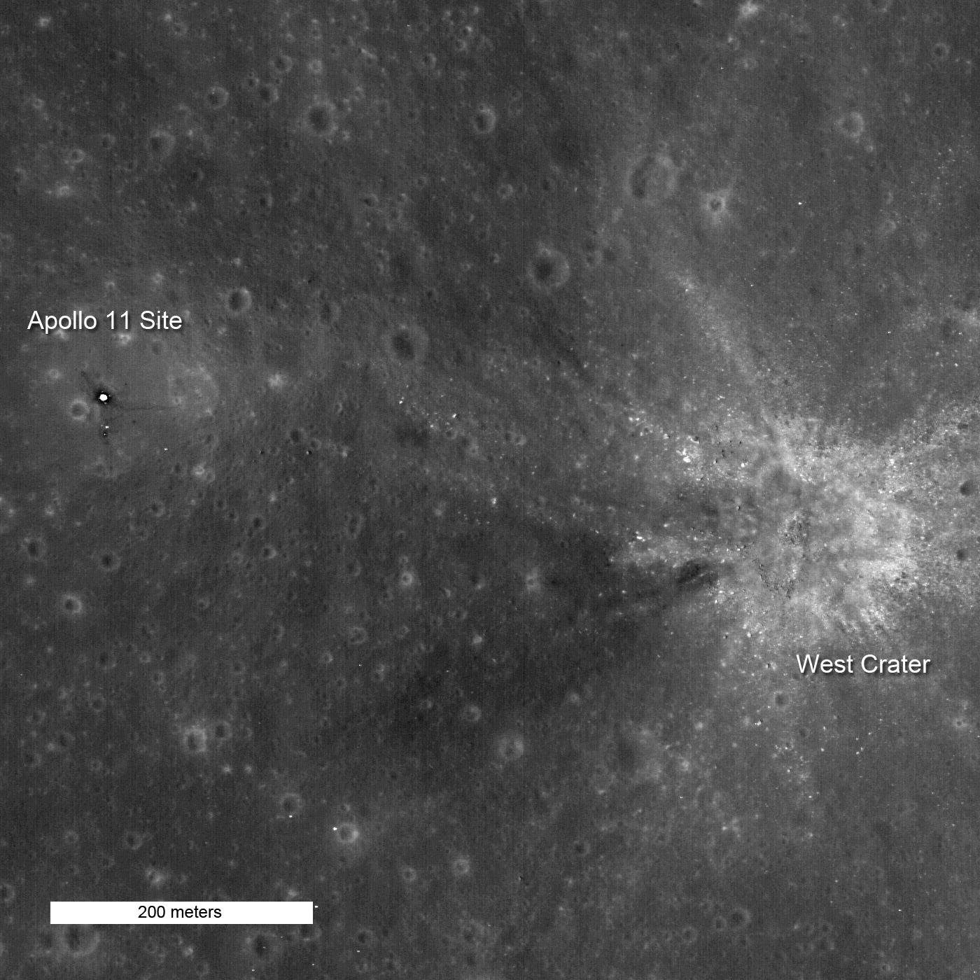
Exhibit A is this view of the Apollo 11 landing site acquired on October 1st (but not released until November 9th) by the spacecraft's high-resolution stereo camera, LROC. It reveals details at the Space Age's most hallowed ground down to about 2 feet (53 cm).
Spend a little time perusing the image at right — or go moonwalking yourself by downloading a larger version or even the original image. The LROC team released a lower-resolution view of the landing site a couple of months ago, but now the spacecraft is in its final mapping orbit, a scant 30 miles (50 km) above the lunar surface.
You can easily see the squarish descent stage of the lunar module Eagle, which looks washed out because of contrast enhancement — look closer, and you'll make out its footpads too. Dark trails are the paths made by astronauts Neil Armstrong and Buzz Aldrin as they walked near Eagle and around the Early Apollo Science Experiments Package (EASEP).

Buzz Aldrin on the Moon
Apollo 11 astronaut Buzz Aldrin deploys the EASEP instrument package on Moon, with the lunar module Eagle in the background.
A few weeks ago, the LROC team released a video tour of the Apollo 17 landing site — amazing stuff! I guess those who still believe that NASA faked the lunar landings would argue that these pictures have been doctored.
It's hard to believe, but just a year ago, five spacecraft were orbiting the Moon — none of them launched by NASA. India and China had one each (Chandrayaan 1 and Chang'e 1, respectively), while Japan's Kaguya and two small escorts, named Okina and Ouna, were mapping the Moon inside and out.
Waiting in the wings was LRO, which began circling the Moon last June. Designed and built at a time when the U.S. and its space agency were firmly committed to returning humans to the Moon, LRO is a recon mission in the truest sense. Its seven-instrument payload reflects NASA's desire to understand the lunar features and resources that could influence the design and placement of future lunar settlements.
For example, the spacecraft's low polar orbit should allow its cameras to record the entire globe with 100-meter resolution and up to 10% of the surface with unprecedented 0.5-meter resolution — good enough to spot hazardous boulders in likely landing sites. (In fact, the view here shows boulders from West crater, which lies out of view to the right in the Apollo11 view above.) A radar mapper and a laser altimeter are gauging the slope and roughness of the terrain. The Diviner instrument has been recording temperatures from pole to pole, and a Russian-built neutron spectrometer is finding the "sweet spots" where deposits of water ice lie buried. Finally, a cosmic-ray telescope has been assessing the hazard that space radiation poses for future explorers.
LRO's early efforts concentrated on the lunar poles, in order to pick the best target for LCROSS and the Centaur rocket that carried both craft to the Moon. But Vondrak hopes that LRO can continue clicking and scanning the lunar landscape for at least two more years. Plans call for modifying the orbit periodically to optimize coverage, ending with the spacecraft in a gravitationally stable "frozen orbit" with a low point almost directly over the Moon's south pole.
No comments:
Post a Comment